We were in Vegas with a Dodge caravan rental car, unlimited miles, and 3/4 of a day to do whatever we wanted.
Although a drug riddled Hunter S Thompson-esque trip through the desert might make for good TV, loading up on mushrooms, acid, and pure ether with your 13-year-old son and hitting the Circus Circus might look bad on the soccer team that had flown us out there (And all I had in my bag was a handful of Zyrtec allergy pills and some ibuprofens).
We came back to the hotel after the last soccer game and laid out our legal, mother-approved options:
– Drive to Mount Whitney, the tallest mountain in the continental United States
– Go see the Grand Canyon
– Climb a mountain in the Red Rock Canyon, 15 minutes from the hotel.
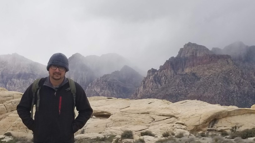
We climbed a mountain called Turtle Head Peak. As we approached the canyon and its visitor center, the mountain poked out of the skyline. It protruded farther and farther, the closer we got to it. At this moment, I still felt like I could make the climb and not make a fool of myself.
The night before, we went to a Ross’ clothing store on our way back from the Hoover Dam. We searched the aisles for clothing to assist us with the Mount Whitney climb, at first. It was supposed to be 18° on the shorter trail at Whitney Portal, one that doesn’t require a permit only granted from an online lottery. But it soon became apparent that in this lonely town on the outskirts of the city of lights, we weren’t coming out with anything but fleece jackets and all-terrain “tennis shoes”. So our decision was made by a man named Ross and his lack of heavy coats during March, in the desert.
First, we visited the welcome center of the Red Rock Canyon. And had many cool exhibits and some really nice clothing for souvenir shoppers that don’t want gambling chips or ladders with pictures of the town’s favorite “lady of the night”.

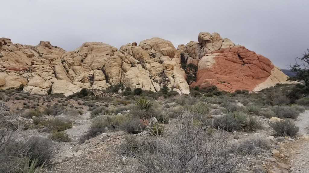
As I left the shop and got back in our car, I looked over the calico rock formations at our desired destination. I swear the thing had further extruded towards the clouds just a little since we had exited our minivan.
On the meandering road that leads to the trailhead, we stopped for a better view of the calico formations. We almost climbed it and instead, but I didn’t want to chicken out of climbing that big ole amphibian in the background.
We drove to the trailhead and found the official sign pointing the way to the mountain. We met an old lady that looked like she wandered off the set of a Golden Girls’ reunion special. This woman asked what trail we were heading out on. We told her turtlehead peak. Before we could get the words out, she shook her head, sized up my pudgy, haven’t-ever-climbed-a-mountain-before-body and said, “You’ll never make it.”
We buried her still-warm corpse in those desert hills and resumed our journey.
After we left Granny and the dust, we happened upon a man who appeared to be around fifty and his wife. “Y’all probably want to turn around at the halfway point.”
One more on the body count.
We were lost in 5 minutes. We climbed by hand on a section that hadn’t been on the trail app reviews. Then we noticed other people walking along a ditch below. Doh!
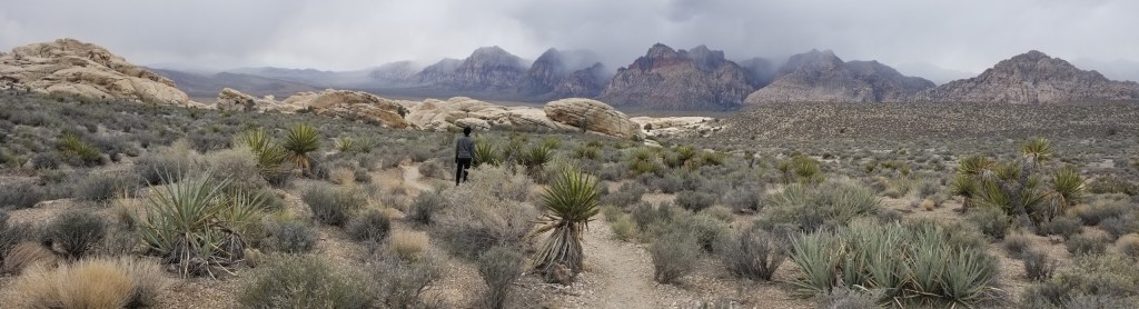
The trail at Red Rock zigs and zags around the floor and fauna, as if state law prohibits pulling up a wild desert bush to create a straight path. I’ve heard that as of writing this, they have now installed trail markers of large rocks and other definite signs of where to go. We were not afforded this luxury.
There we were, attempting to follow a path through a strange, and quite foreign land for a Georgia boy, and we didn’t know about how people marked trails with spray paint and trail markers. We soon discovered our ignorance when we found ourselves removed from the trail, standing fifty yards away from the few people we saw climbing that day. Two young women showed us how to know where the trail was. There were two colors of marker that day. Orange and white, we never did figure out which color signified the easier trail. A few months before, a group of college students were hiking Turtle Head Peak when one of their friends slept off the side and silently fell to her death. The young people swore that they had not heard the girl plunge into the depths of the canyon.
I’d read this story before we left the hotel. Now, we clung to half submerged rocks, any bushes that didn’t slit our wrists, and we were climbing, hands and knees, even, up a steep embankment of loose gravel and thin desert dirt.
My feet slipped under me. I reached out to steady myself and grabbed the plant with three inch barbs sticking out of its stems. Ouch!
At one moment while I maneuvered around a piece of the mountain that crowded the trail a bit too much, my backpack, which was overfilled with food and our jackets, struck the side of the rocky wall and twirled 180° almost falling off the side of a 50ft cliff.
Did I mention that during all of this I was sucking wind like I’d never in my life? All of our climbing was being performed in 25 yard increments with a sit-down rest. This made the trip a little harder for my son, who could have most likely ran up the trail to the top .
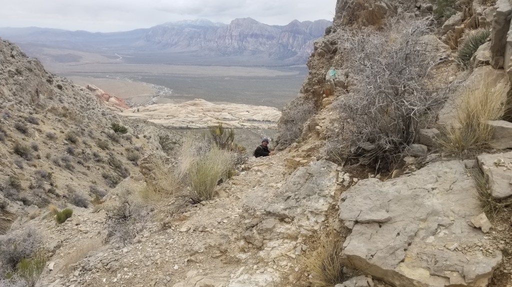
I finally cleared the steep course section and made our way to a well-marked path with a steady uphill to the top. Our journey upwards allowed us to walk with the mountain rising on our right, and exposure to a fall that would have rolled us down to the bottom of the mountain to our left. Towards the end, almost to the top, we had to climb one more super steep section that was covered in mud. One slip during this moment and we would have tumbled to our death.
The air is thinner on that mountain than in North Georgia. My lungs begged for oxygen. I gasped at rest for several minutes of sitting down. We made our final push to the top up the trail before us with loose rock and sections of deep, slick mud.
I’ll admit we took a chicken trail around the section with a 1000ft-ish exposure with a sheer drop. We both started that section and took to the path created by other hikers who also didn’t need the adrenaline rush before the top .
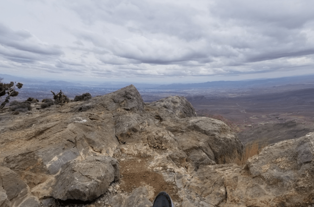
Let me cut to the chase… The view from the top is outstanding. I’ve never laid eyes on a more awe-inspiring vista in my life. To my left was the skyline of the Vegas strip and all the surrounding neighborhoods, but quite higher than the tall tower in Vegas that resembles the Space Needle in Seattle.
We sat for a long time drinking in the mountains, crawling around near the edge (albeit 20 ft from the edge), and watching a family beg their dad not to eat his Funyuns near the sheer dropoff of the cliff.
It took two hours to descend the trail. The loose churte prevented us newbies from hauling ass back down, that and my inability to actually “haul ass”.
I can’t recommend this trail enough to anyone seeking adventure, though. It had breathtaking views, harrowing climbs, and terrain unlike anything you’ll experience on the east coast. It took us about 5 hours to climb up and down. Thus preventing us from holding the FKT (fastest known time) by almost 4 hours.
-Nate

Great read and thank you for writing the story!
LikeLike